


FlyQ InSight app for iPhone and iPad
Developer: Aircraft Owners and Pilots Association
First release : 13 Apr 2012
App size: 112.86 Mb
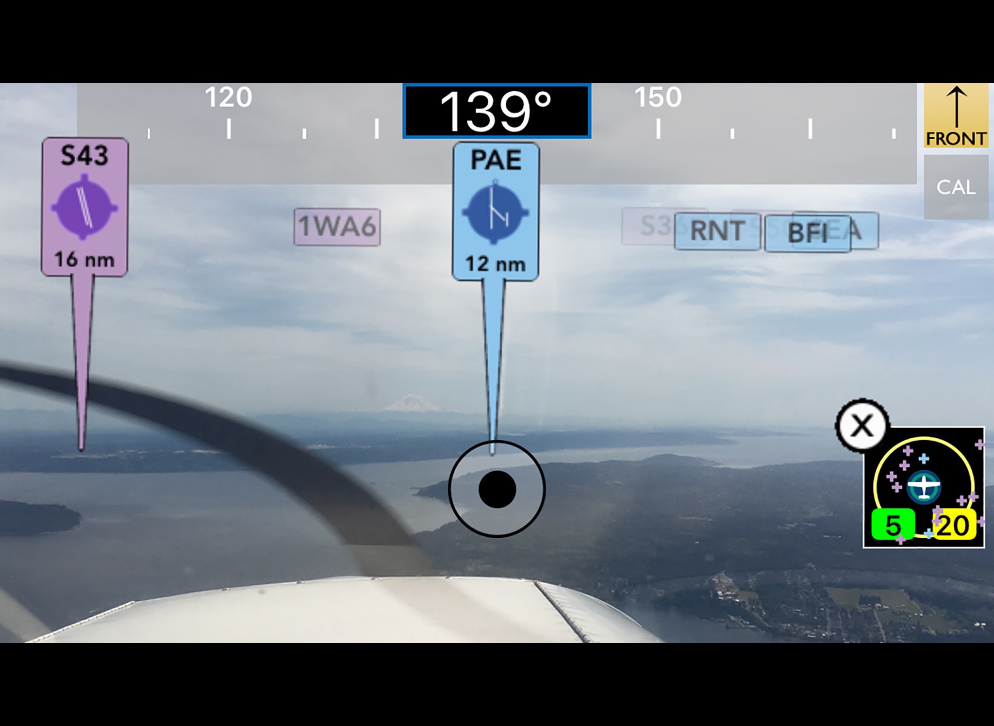
FlyQ InSight is the new, absolutely amazing augmented reality aviation app for the iPhone and iPad. Using just the camera in your device, it magically overlays live video with markers showing the position and distance of nearby airports! Never have trouble finding airports again, even in poor weather or night flying!
InSight shows incredible views and a simple tap captures the image. Use the Photos tab to view and share your favorite pictures via Facebook, Instagram, Twitter, etc.
Filter by type of airport and distance range.
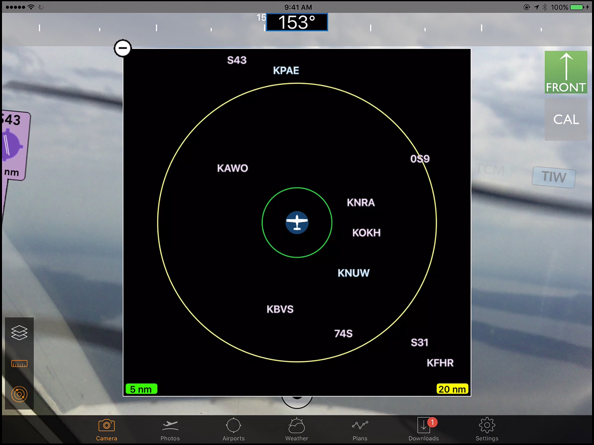
Use the unique 2D view to show a "top down" view of nearby airports in relation to where youre pointing your device.
Not only that, FlyQ InSight has aviation weather, airport info, FBO info, fuel prices, and flight planning capability to put tremendous power just a click or two away. You can plan a flight on your iPhone with an auto-router that wind-optimizes your flight to get you there as fast as possible. Victor Airways, GPS Direct routing, Jet Airways—FlyQ InSight is ready for it all.
FlyQ InSight shares flight plans, pilot profiles, and aircraft profiles with your iPad running FlyQ EFB and your PC or Mac using FlyQ Online.
Using FlyQ InSight is simple because all major functions are always just a tap away.
Airport Information
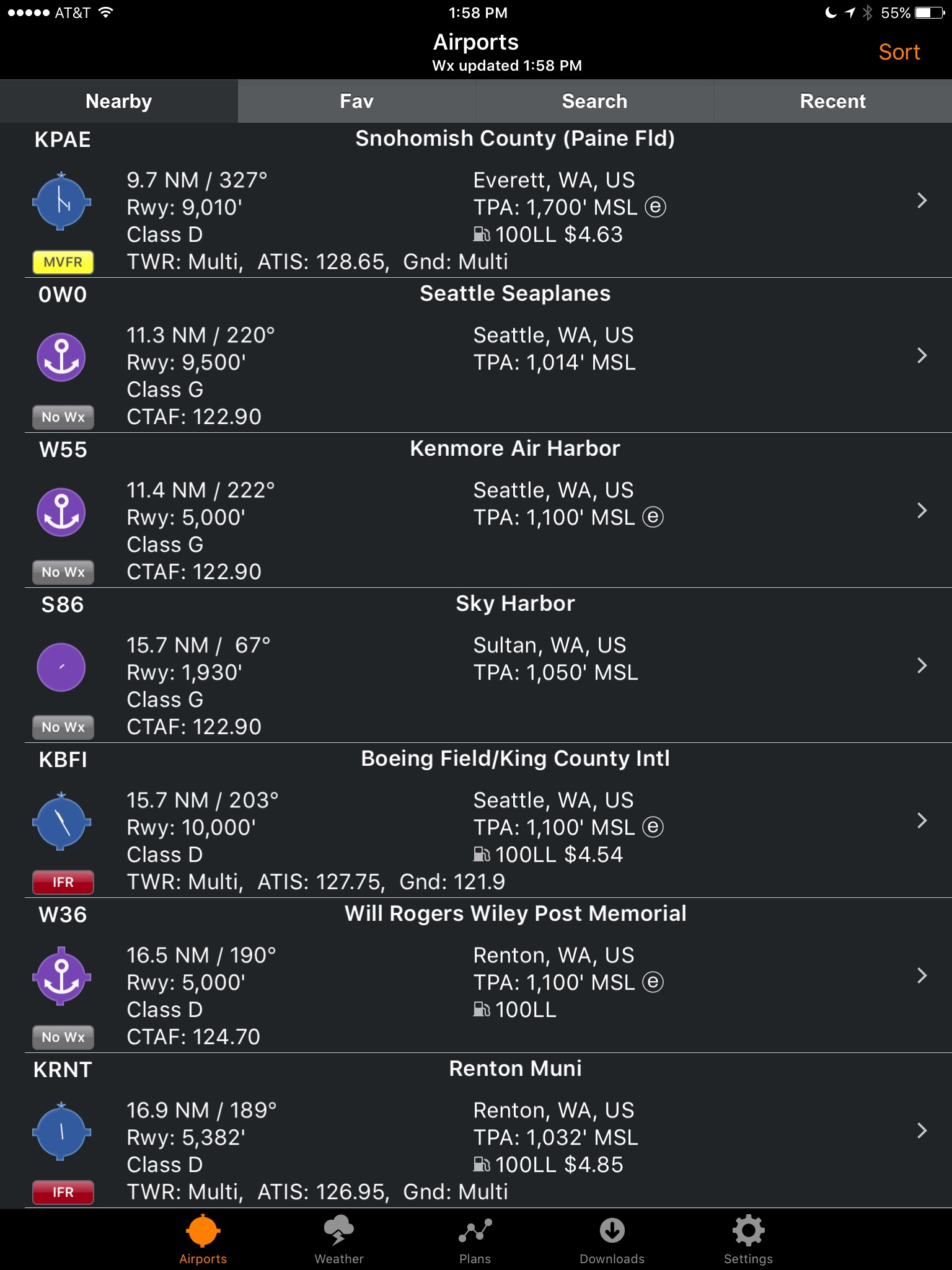
Start FlyQ InSight and within about 3 seconds it finds the nearest airports and displays succinct weather, fuel, and operational details about them—without even tapping a button. Or use the Search feature to find airports by ident or name. Even browse by state/city to select airports without typing. Want more info about an airport? Tap and all the details you need (but no excess clutter) appears instantly. On the first airport page, you immediately see operational information, fuel prices, runways, navaids, the FAA airport diagram (if applicable) and an embedded satellite map image of the airport. Want to call the local ATIS? Tap the phone number and your iPhone quickly connects you. Tap the weather tab and see the current temperature and sky conditions, a Nexrad radar image of the area, the nearest METARs and TAFs, winds-aloft, and even an official Lockheed Martin or DUATS weather briefing. One tap zooms the METARs, TAFs and weather graphics to full screen, large font versions that anyone can read—even in turbulence. Another tap gives you an easy-to-read 7 day forecast. Quickly find the FBO details you need—fuel information, telephone numbers, rental cars, nearby attractions and more. The Favorites feature gives quick access to commonly-used airports.
Weather Information
Tap the Weather tab and FlyQ InSight instantly locks on to your GPS position and displays temperature, Nexrad images and local METARs and TAFs. Or choose from a large gallery of US and Canadian weather graphics, many of which are animated. Quickly check the weather anywhere on the globe by entering an airport ident, city name, even a zip code. Of course, FlyQ InSight keeps track of your recent selections for quick future access and stores graphics and METARs/TAFs on the phone so they’re available even when you’re not connected to the Internet (such as in flight).
Flight Planning
No time to plan a flight? Give us 30 seconds and watch FlyQ InSight assemble the perfect wind-optimized flight plan. Tell FlyQ InSight where to depart, where to land, and how to fly there (Victor airways, Jet Airways or GPS Direct) and FlyQ InSight plots the whole course including all the navaids and intersection—not a simple straight line. It even uses the winds-aloft forecast to give you the ideal altitude for each leg of your trip. To make your life easier, FlyQ InSight automatically requests an official Lockheed Martin or DUATS weather briefing so you’re good to go. Filing the flight plan takes one tap and about 3 seconds. FlyQ InSight remembers your recent flights and home airport so you can often plan a flight by picking from a list of recently used airports rather than typing.
Latest reviews of FlyQ InSight app for iPhone and iPad
Works okay, but not sure how useful it is. Doesnt seem to have a moving map, which I think people would want. A moving map like the Forelight or Garmin iPhone app would be nice.
Very handy, great UI, actually switched from ForeFlight.
When I first installed the application I was quite frustrated by the lack of support for Canadian pilots but after chatting with a friendly gentlemen at technical support and following his instructions I was able to use the App for planning my trips between my local airports! Great App, it is now my favorite flight planning App. Thanks FlyQ!!!!
Missing major GA airport in Canada. Cannot create any flight plan unless registered to DUAT, which requires a FAA license #.
Cant search airports by state. Wow, major shortcoming. Why aopa keeps this low quality app and not updating is a mystery. The old app was a lot better than this junk.